St Clair County, Missouri

- Formed: February 11, 1835
- County Population 1860: 6,235
- Slave Population 1860: NA
- Civil War Engagements
– Burning of Osceola, September 23, 1861
Image courtesy of Wilson’s Creek National Battlefield
St. Clair County, Missouri, is located along the Osage and Sac Rivers. It contains many creeks that provide additional fresh water. These include: Hogle’s Creek, Bear, Turkey, Galinipper, Coon, Brush, Weaubleau, and Bush Creeks. The abundant water and prairie grazing grasses allowed settlers to successfully raise livestock, including horses, cattle, sheep, and pigs. The soil permitted growth of millet, corn, wheat, buckwheat, flax, oats, barley, rye, hemp, cotton, and sorghum. The area contains natural coal, silver, iron, lead, copper, and nickel deposits, as well as abundant limestone for construction.
The Osage who were the native residents of St. Clair County, but the tribe were coerced into leaving the area in the 1820s and found residence in Kansas. The first non-Native American settler was Jacob Coonce, a hunter who traveled through the area in 1827, and who permanently settled in present day St. Clair County in 1831. Other early settlers included Ebenezer and William M. Gash. William held the first session of the County Court in his home. Other early settlers were Joseph Montgomery, the first judge, in 1834, Jesse, Charles, and Lindsey Applegate in 1834, Avery B. Howard, the first mill owner, David Hoffman, the first ferry operator, in 1836, John Perry, John Armingtrout, Robert and John Burch, and Nathaniel Bell in 1835-36, Dan, Joe, and Calvin Waldo, the owner of the first store, James Gardner, the first Justice of the Peace, Robert Gardner, Burdett Calm, Thomas Piper, Daniel Brandt, Nicholas McMinn, Jonas Musgrave, Henry Earl, Simeon Poston, and Joseph Coslow. The early settlers depended on agriculture, wild game, and trade with Harmony Mission, a Christian mission in Bates County.
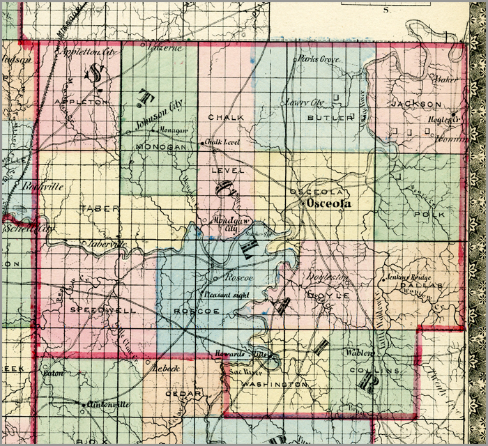
The St. Clair County area was part of Rives (later Henry) County, which was established February 11, 1835. St. Clair was established as an independent county on February 15, 1841. It was named after Revolutionary War General Arthur St. Clair. Three St. Clair County men, Joseph Montgomery, Calvin Waldo, and Thomas F. Wright, named the county seat Osceola. St. Clair boundaries were debated for four years, but finally settled on March 28, 1845, when six townships were established. These were: Monegaw, Speedwell, Washington, Polk, Osceola, and Jackson. For the first several years of its existence, the St. Clair County government focused on building roads and bridges and clearing out swamp land. By the 1850s, the population had reached over 3,500 people. At this same time, a large group of St. Clair County men traveled to California in a mostly unsuccessful search for gold.
In the 1850s, political debate centered on whether Kansas would be a slave or a free state when it entered the Union. Though St. Clair County residents intensely debated the issue, they were not directly involved in any of the raids. Kansas jayhawkers conducted constant border raids, and when the Civil War began in 1861, border warfare only intensified. St. Clair County residents fought for both armies. Union supporters fought under St. Clair resident Captain Benjamin F. Cook in Company D, 16th Regiment, Enrolled Missouri Militia, which formed August 2, 1861. There were no major battles in St. Clair County Boundaries, though residents suffered much devastation. Osceola was burned to the ground under Jim Lane’s Kansas Jayhawkers, and all county records were destroyed in 1864. When the war ended, St. Clair County began to rebuild itself. Freed slaves left the county, causing the population from 1860—6,812 people—to decrease in 1870—6,742 people. Successful silver mines and a cheese factory in Appleton City sped recovery, and by 1880 the population was over 14,000 people.
 Browse all collections in St-Clair County
- Consulted:
- History of Henry and St. Clair Counties, Missouri (Clinton, MO: Henry County Historical Society, 1968).


